This week’s entry is quite brief. We moved a lot – three passages in a week. Plus, I’m sick with a chest cold. The cold itself isn’t that bad, but the knowledge that I am the first one on this trip to get sick is. I am supposed to be the strong one. Anyway, uh, sorry.
Also, I changed the look of the blog. I’m not sure I like it. Do you? Let me know. Really.
Also, sorry this is late.
Monday 6 NOV
Today’s winds are from the south which makes them warmish (not really) but impassable for our aim. The winds will turn by tomorrow and come from the north. This will make them good for travel for us, but it will also make them colder and a bit more turbulent. Win-Lose, I say. Plus, it’ supposed to rain in the afternoon. Luckily our trip is short to Norfolk/Hampton – only 90 miles – so our suffering will only last 12 – 16 hours… The hot showers will make up for it.
Glenn and I take one last beach walk on Asscheek Island and bid it a fond farewell. I will miss you, you empty, beautiful beach.
Tuesday 7 NOV
Passage: ASSATEAGUE ISLAND, MD to CHINCOTEAGUE ISLAND, VA
Wednesday 8 NOV
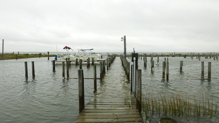
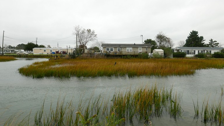
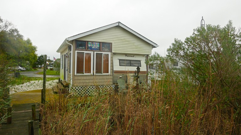
Chincoteague Island and Assateague Island… It sounds like they could be related, right? Sisters, even. I always thought so, but these two islands could not be more different. Chincoteague Island sits in the shadow of Assateague, completely in Chincoteague Bay. It has no ocean front, is densely inhabited and not by ponies. It is relatively poor and sinking. We are tied up at a marina at the southern end of the island. Though we are in the midst of waterfront lots, this end of the island is entirely comprised of trailers on lots in parks, the most run down one being closest to us. As we walk north three miles into town the parks get better (the trailers are newer, there are some with house-like enclosures, etc.) and so do the lots. By this I mean they get less wet. We happen to be walking at high tide and the flooding at the southern end of the island is alarming. When we see Captain Bob’s sunken marina it becomes clear that this isn’t just a high tide issue, though. The docks are completely underwater by at least a foot or two. This is evidence that the water levels here used to be significantly lower. (There is no point in debating reasons.) Is anyone noticing? Chincoteague presents a glimpse into the path of eventual collapse that will accompany a blind eye. We witness, as we walk further north into town, no effort to stave off the water. In fact, there are new construction projects, much of it too low to the ground, signaling a complete denial of the south end’s evidence. It is shocking… but life continues.
In town Glenn and I eat a luxurious lunch of seafood chowder and pie a la mode, a reward for our six mile walk, or maybe to soothe my heartache. The downtown is small and quaint with a building stock that looks to have been mostly constructed in the 1930 – 40’s(?) It looks like every other town of this generation on the east coast. That is, judging by the architecture, there is no suggestion that we are near water, views, breezes. Why architects?
In the evening we get a call from the Harbormaster telling us he’s not charging us for the stay and wishing us a good trip. Thanks, Chincoteague! Why are the poorest places the most generous?
Thursday 9 NOV
Passage: CHINCOTEAGUE ISLAND, VA to HAMPTON, VA
Friday 10 NOV
We leave the boat in the late morning after a long rest. First stop: showers. We are anchored by the Old Point Comfort Marina, and though we are not on their property or paying them a fee, they let us use their facilities with showers. Thanks, OPM! (Is the south actually friendlier than the north?) Starving, we eat an early lunch and head out to Fort Monroe, a stone’s throw away, for the day.
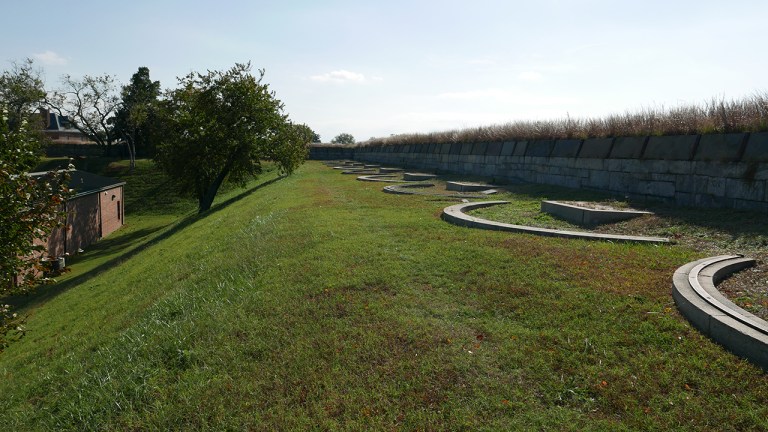
Fort Monroe is a decommissioned military fort that used to be one of the defensive structures protecting the entrance to the Chesapeake Bay. It’s huge. It’s also quite interesting in that it’s a star fort (aka. bastion fort) with an actual moat around it. The design of the shapes of these forts is based on artillery technology for straight line shooting (arrows and, later, powder fire). Developed in Europe throughout the middle ages, the star shape came to maturity in the fifteenth century and was wildly successful as a defensive structure against attacks. I always find it strange, however, that these forts were constructed here given the nature of the battles fought (and settlements designed) in the United States. It’s all too long to get into, just to say that these forts tend to feel like out-of-place imports when I see them here.
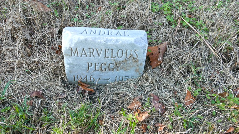
Anyhoo, we go to the fort which is now… an apartment/townhouse complex. Yep. The protective walls and moat are still in place, but all of the buildings within are now domestic residences with kids’ toys, barbeque grills, grassy quads, shady walkways. It makes sense. Much of the complex was always residential (soldiers’ and officers’ quarters), it just feels odd to dwell domestically side by side with cannons and shooting towers. You know, life inside a war machine. Or does it? I suppose people who live in, or with, war have to continue having a life, no? As such, one of the more tender parts of the fort is the pet cemetery. The tiny graves sit on top of the ramparts alongside the concrete pads and cannon tracks used for heavy fighting. Engraved with loving remembrances, the small headstones speak of family and community forged within a violent (outer) world. Who are humans that they can simultaneously love a dog and kill a human? Actually, scratch that. Dogs are much better than humans.
Saturday 11 NOV
Today: grocery shopping, laundry, the basics before a passage…
Sunday 12 NOV
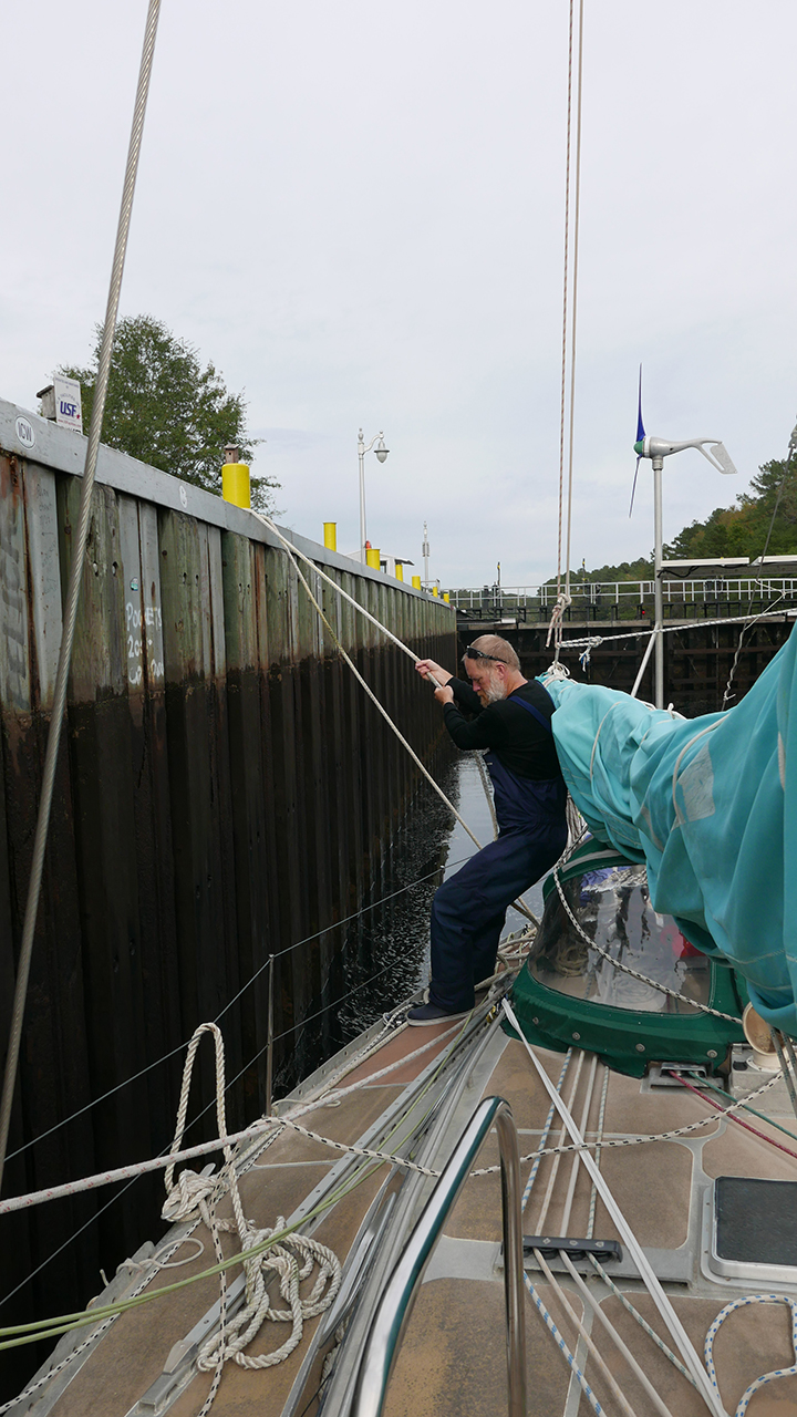
Passage: HAMPTON, VA to DISMAL SWAMP CANAL
Glenn’s
LogGybe Talkin’ (Thanks, Mike! I LOVE it!)Tuesday 7 NOV – Sunday 12 NOV
OCEAN CITY, MD to HAMPTON ROADS, VA
Our sails from Ocean City, MD to Chincoteague Island and from there to Hampton Roads/Norfolk, VA were quick ones. The second passage, which was the longest of the two (75 miles) was completed in just under 12 hrs, with only very little motoring at the end. This is a good time for us, averaging over 6 knots. At times we were surfing down waves at over 8 knots. The sailing was thrilling! Both of these sails were ‘day sails’ – conducted during daylight hours and they both required the precise timing of a ‘weather window’ – a 12 – 15 hour window in which the conditions were right for a quick passage. For both of these passages we had the wind on a stern quarter or directly behind us and the seas on our beam our somewhere behind us. Wind conditions were generally 15-20 knots with the occasional higher gust and seas 4-6’ with a larger sets (9-10’) every so often.
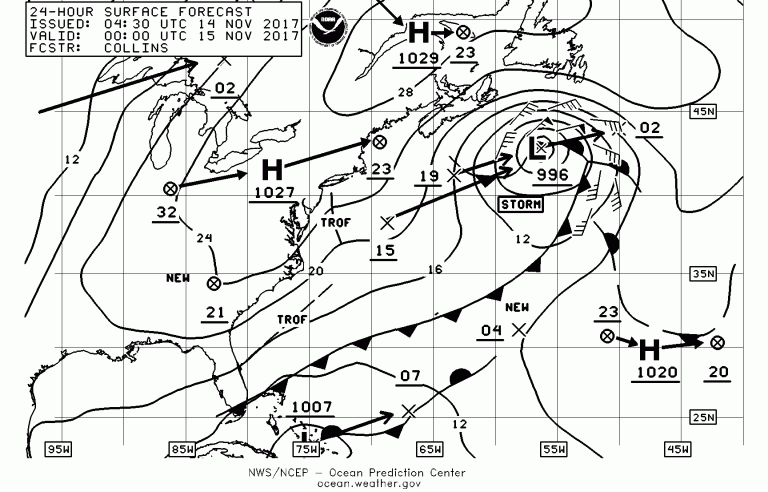
We are fully immersed in the autumnal weather system. The weekly pattern has been a stationary high followed by a strong cold front from the west bringing gale force (35 knots) or close to gale force winds from the north. This usually blows for a few days. The wind is from the right direction for us to move south, but that’s not the sort of wind and waves (15-20’) that we would choose to go out in. So we wait for the conditions to settle down – we wait for our ‘window.’
So, how do we find this ‘window?’ What tools do we use besides empirical observation to understand and forecast the weather? There are three fundamental tools we use for this purpose: GRIB files, text forecasts, and weather faxes. The first and most useful for us are GRIB (GRIdded Binary) files. GRIB files hold a lot of information but are small (so easily downloaded over a slow connection like sat nav.) We can download them and view them in many different ways; through an app on our phones or iPad or on a laptop when connected through the phone or sat nav system. They are forecasting files generated by the NOAA super computer running their GFS (Global Forecasting System) model. (I believe a new one is generated every 6 hours.) Using them over the past 5 months I’m astounded by their accuracy forecasting changes down to the hour – if not the minute. Really…it’s magic…like predicting the future. The data they carry shows wind force and direction, gust force, precipitation, air pressure gradient, location of high and low pressure centers, and average wave height and direction. When downloading you can specify duration (1-12 days) and interval (1,3,6…hours.) You can also choose other parameters, such as the scale or gradient of the information – useful for controlling file size when we are on a slow connection like sat nav. If we have phone service like we do along a coast, I can download these on demand and simply view them with an app on my phone.
In addition to GRIB files the two other sources; text forecasts and weather faxes are also produced by the NOAA. The first is a text based zone forecast for the region we are sailing in. The other is a graphic document – typically for a much larger geographic region like the North Atlantic, showing larger trends in the forecast system. Both of these documents are produced by professional meteorologists interpreting the GFS model and other data. They tell us many things that we as lay people are unable to identify about the models such as the location and intensity of fronts, developing gales and/or storms and their prevailing direction. The most amazing thing about all of these tools besides their accuracy is the fact they are completely free. (…well paid for by our tax dollars, but certainly worth it!)
By studying this information daily and looking at trends in the weather we have been able to identify our ‘windows’ for more comfortable (Anca and Ava would doubt this!) and quick passages. On both of these passages we were able to complete them and get into a new anchorage or harbor in daylight a few hours before the weather turned really nasty.